
Gregory C. Eccleston
Monsieur l’ambassadeur de France.
Mesdames, mesdemoiselles, messieurs…
Bonjour !!!!!!
Si nous sommes reunis aujourd’hui dans cette salle, ce n’est pas pour célèbrer l’union de deux êtres, mais belle est bien pour célèbrer le bicentenaire de la première publication de la carte de l’Australie.
Je m’appelle Greg ECCLESTON.
This is a brief story of the development of a map of Bass Strait showing the routes of the early navigators – from James Cook who skirted the edge of Bass Strait in 1770, to early 1803.
As you would know, Bass Strait is a busy thoroughfare, fraught with many hazards such as islands, rocks, reefs and shoals – not to mention treacherous swells – that over the years have claimed many thousands of lives on the coasts of Victoria and King Island (especially).
Once the existence of Bass Strait had been established, enabling a shorter travel time from England to Sydney – by avoiding the need to travel around Tasmania’s southern coastline – it became urgent to plot Bass Strait’s hazards and to locate safe havens for sailing vessels. This was accomplished in the space of five years.
In acquiring primary evidence for the mapping of the routes of the early navigators of Bass Strait, I encountered a number of difficulties. For instance, I could not find George Bass’s charts: they no longer exist – necessitating reliance on secondary sources; but in this case some of Bass’ charts had been copied by Matthew Flinders who, fortunately, had excellent draughting skills. See Figures 1, 2 and 3.
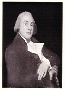
Figure 1 Ship’s Surgeon, George Bass.
A painted (miniature?) portrait is the only authentic image of Bass.
In the 1890s a photograph was taken; the painting has since been lost.
(Image from Keith Macrae Bowden, George Bass1771-1803, OUP, 1952, frontispiece)
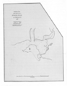
Figure 2 Matthew Flinders, Western Port on the S. Coast
of Nw. South Wales from Mr. Bass’s Eye-Sketch, 1798
(Aaron Arrowsmith, London, 1801)
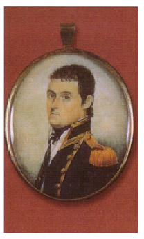
Figure 3 Matthew Flinders RN
Miniature portrait painted on ivory,
(Mitchell Library, New South Wales, ML MIN 52)
To me, the most helpful charts were those showing the route of the ships. See Figures 4, 5, 6 and 7.
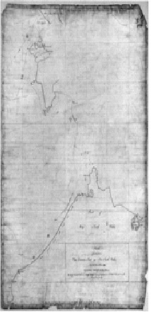
Figure 4 Matthew Flinders’ 1798 manuscript sketch, entitled
Sketch of the Parts between Van Diemens Land and New South Wales,
(UK Hydrographic Office Chart y65 Shelf X)
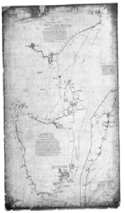
Figure 5 Flinders Sketch, 1798-9,
(UK Hydrographic Office, Chart y49/1 Shelf X)
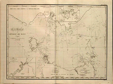
Figure 6Carte Générale du Détroit de Bass dressée par L. Freycinet,
Commandant le Goëlette le Casuarina années 1802 & 1803.
(NLA Map RaA2. Part 8. http://nla.gov.au/nla.map-raa2-s8)
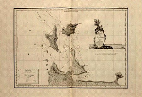
Figure 7Carte des Îles Hunter dressée par L. Freycinet,
Commandant le Goélette le Casuarina,
d’après ses observations et celles de M. Boullanger,
Ingénieur Hydrographe, Décembre 1802.
(NLA Map RaA2. Part 10. http://nla.gov.au/nla.map-raa2-s10)
Nicolas Baudin (Fig. 8) was commander-in-chief of the 2-vessel French expedition commissioned by Napoléon Bonaparte and sent on a voyage of discovery to New Holland in 1800. Baudin commanded the Géographe, and Emmanuel Hamelin (Fig. 9.) commanded the Naturaliste (Fig. 10.). The crew included the very talented sub-lieutenant Louis Freycinet (Fig. 11.)
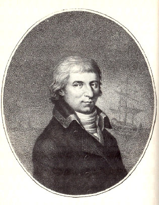
Figure 8. Captain Nicolas Baudin,
by [Joseph?] Jauffret, c.1800
(Musée de la Marine)
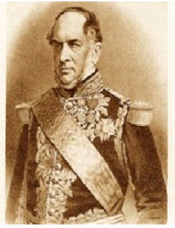
Figure 9 Emmanuel Hamelin (in later life)
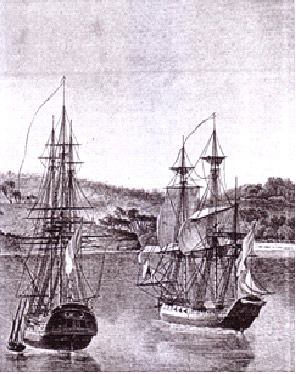
Figure 10Le Géographe and Le Naturaliste
(after the drawing in Freycinet’s Atlas of 1807)
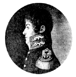
Figure 11 Louis-Claude de Saulces de Freycinet
(From an engraving of the original portrait in possession of the de Freycinet family)
Included amongst many French scientific discoveries and achievements off the coasts of eastern and northern Tasmania, and the southern and western coasts of mainland Australia, was the charting of the coast of Victoria west of Wilson’s Promontory by the crew of the Géographe, whose route near the Victorian coast is shown in Fig. 12.
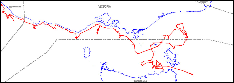
Figure 12 Route of the Géographe approaching and along the Victorian coastline
28 March – 2 April 1802
(Adapted from Louis de Freycinet, Carte Générale du Détroit de Bass
in his Atlas (Navigation et Géographie), Paris 1812 [sic 1814])
This image © The State of Victoria, Department of Sustainability and Environment 2010
Reprinted with Permission
My recent investigations focussed on Baudin’s forgotten manuscript charts of the Victorian coastline, rather than on the published maps of Freycinet, which other speakers today have covered in detail. There are many more manuscript charts from Hamelin’s crew that are kept in the Archives nationale in Paris, that await inspection by scholars! Here is a list of those manuscripts: Fig. 13.
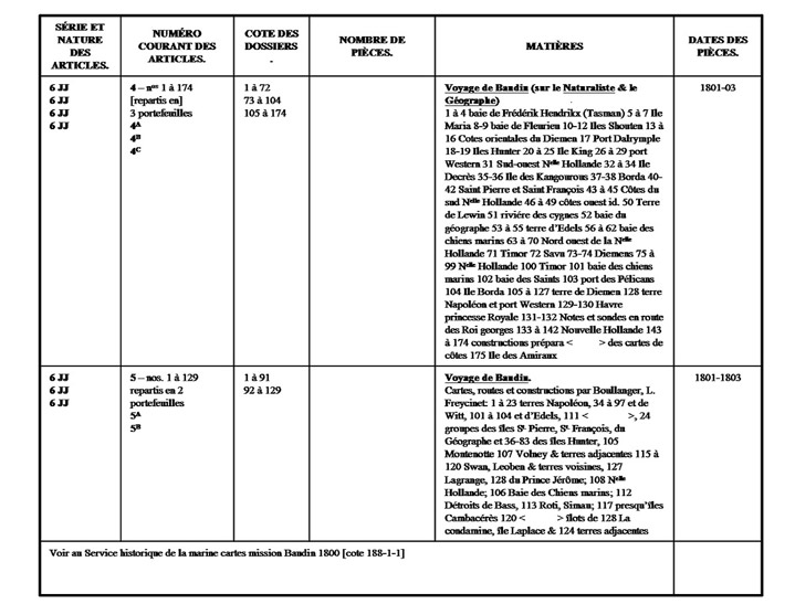
Figure 13 Table of Manuscript Charts of the Baudin Expedition,
being Part of Pages 8 and 9 of the Index to Marine 6 JJ, Archives nationales, Paris
It is extraordinary that these Baudin manuscript coastal charts, drawn collaboratively ‘on the spot’ by Baudin and his officers, and in particular the place names on these charts, have been totally and intentionally disregarded (or carelessly overlooked) by almost all historians for 200 years. Fig. 14.
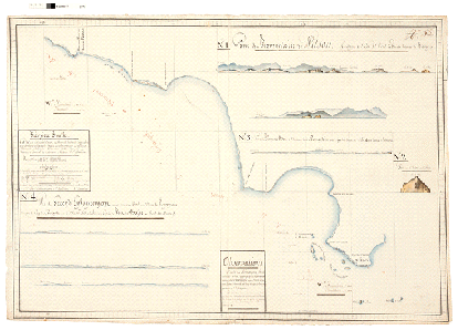
Figure 14 Chart 55 (reference Marine 6 JJ 4B, pièce no. 75)
(Document conservé aux Archives nationales, Paris)
Shamefully, Baudin’s place names were replaced by names chosen by zoologist François Péron and these spurious names appeared subsequently on charts drawn by Louis de Freycinet, a sub-lieutenant. Perhaps our indifference (until recently) can be attributed to a long-standing AngloAustralian contempt for the French, coupled with a declining interest in Australia by the French after suffering major military and naval set-backs during the Napoleonic Wars. Figs 15, 16 and 17.
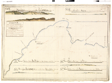
Figure 15 Chart 56 (reference Marine 6 JJ 4B, pièce no. 76)
(Document conservé aux Archives nationales, Paris)
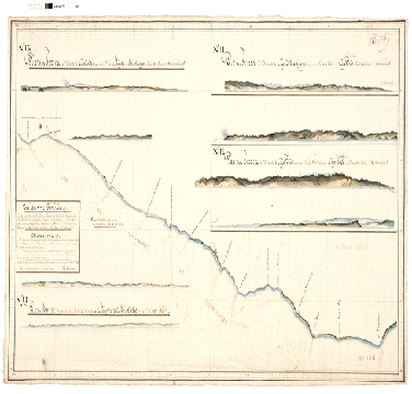
Figure 16 Chart 57 (reference Marine 6 JJ 4B, pièce no. 77)
(Document conservé aux Archives nationales, Paris)
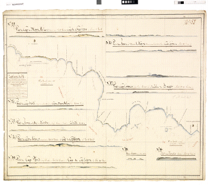
Figure 17 Chart 58 (reference Marine 6 JJ 4B, pièce no. 78)
(Document conservé aux Archives nationales, Paris)
A question of priority!
In scientific disciplines, such as zoology and botany, there are strict internationally-recognised principles for the naming of a taxon (family, genus, species, etc). An important and long-established principle within the International Code of each discipline is the Law of Priority: ‘The valid name of a taxon is the oldest name applied to it.’ Equally, Baudin’s original names, now retrieved from obscurity and revealed, should be regarded by place names authorities as having priority over those given by Péron and Freycinet. Where Baudin named identifiable features before the English, his onomastic choices should be restored and respected.
I have written a paper describing Baudin’s manuscript charts of the Victorian coastline and this appeared in a recent issue of The Globe.
What sparked my interest in Baudin and Freycinet?
In connection with the celebration of the 400th anniversary of the first known charting of part of Australia’s coastline – by Willem Janszoon in the Duyfken in 1606 (Fig. 18.), of part of the western coastline of Cape York Peninsula – each state and territory was encouraged by the ‘Australia on the Map 16062006’ (AOTM) organisation to celebrate the charting of its own coastline in various ways.
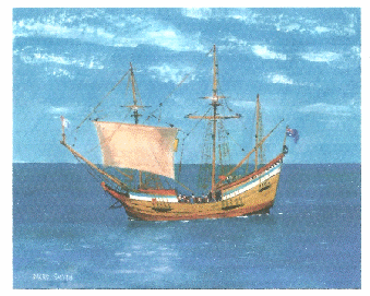
Figure 18 Dacre Smyth’s Painting of the Replica of the Duyfken
As a member of the Victorian Steering Committee of AOTM, I proposed that we produce two things:
-
A story of the Early Charting of Victoria’s Coastline, which could be placed on the web. I volunteered to write this, which the Steering Committee accepted.
-
To prepare a map of the routes of the early navigators along Victoria’s coastline, for possible use in secondary school classrooms (either History or Geography), provided that someone – perhaps a cartographer in the Office of the Surveyor-General – did the cartography. It was quickly realised that it would be much more useful if the area to be covered were to embrace the whole of Bass Strait. The Surveyor-General of Victoria, John Tulloch, was approached and he willingly agreed to allow his cartographer, Rolando Garay, to prepare a map at a reasonably large scale (1:500 000) of the routes of the early navigators through Bass Strait, subject to fitting in with his official departmental duties. I offered to ascertain the routes and give them progressively to Rolando.
Designing the map of the early navigators of Bass Strait
Some of the decisions we had to make during the preparation of the map were:
1. What scale would be appropriate to reveal the wealth of information provided? (1:500 000.)
2. Do we restrict the extent of the map to Victorian waters, that is, only as far south as Latitude 39º 12′ (NO), or do we take in the whole of Bass Strait? (YES – especially when it was realised that there was no map of Bass Strait existing at a reasonably large scale.) [It has now provided the department with a base map for other Bass Strait purposes – location of ship wrecks, location of oil and gas wells, fishing, etc.]
3. Do we include up-to-date satellite imagery? (NO – Satellite imagery coverage was incomplete and in any case did not fit exactly within the outline of the coasts.)
4. What is the best projection to use? (Lambert Conformal Conic with Central Meridian of Longitude 145º E and two Standard Parallels of Latitude.)
5. What datum? (GRS80 Ellipsoid using the Geocentric Datum of Australia 1994 – otherwise known as GSA94.)
6. Will the (paper) map be suitable for use in schools? (Limited, because of its size.)
7. Can the information be available in digitised form, layered so that teachers and scholars can add or remove layers of information? (YES! This is now being undertaken by GTAV and HTAV with funding from the Department of Sustainability and Environment.)
8. Could the achievements of the navigators be set into ‘timely’ context, by including Aboriginal placenames for southern Victoria and northern Tasmania? (YES! This was something that I was keen to do! But it involved time-consuming research of the literature for the best sources of this information.)
9. Although anachronistic, should the current state boundaries be shown? (Yes, says John Tulloch, the Surveyor-General!)
I was fortunate in being able to inspect cartographic material at the UK Hydrographic Office in Taunton, England, and at the Archives nationale in Paris – to clarify and resolve certain conflicting pieces of evidence.
Electronic version of the map for use in the classroom
The map was completed and ready for producing ‘on demand’ in December 2010. It is now on sale at a few outlets, such as Information Victoria, MapWorks and the Melbourne Map Centre. In the meantime, the GTAV and HTAV, with funding from Victoria’s Department of Sustainability and Environment, are preparing class notes for secondary school teachers of Geography and History respectively, for using the electronic version of the map in the classroom.
I shall now show three versions of the finished map: Figs 19, 20 and 21.

Clicl to enlarge
Figure 19 The Early British Navigators of Bass Strait
This image © The State of Victoria, Department of Sustainability and Environment 2010
Reprinted with Permission

Click to enlarge
Figure 20 The Early French Navigators of Bass Strait
This image © The State of Victoria, Department of Sustainability and Environment 2010
Reprinted with Permission

Click to enlarge
Figure 21 The Early Navigators of Bass Strait
This image © The State of Victoria, Department of Sustainability and Environment 2010
Reprinted with Permission
I conclude by showing Matthew Flinders’ Fair Chart Australia or Terra Australis (Fig. 22.), two versions of Louis Freycinet’s Carte Générale de la Nouvelle Hollande of 1811 and 1814 respectively (Figs. 23. and 24.), and finally a copy of the map of Bass Strait, drawn by Flinders, which was given to Freycinet by the American consul in the Ile de France (Mauritius) (Fig. 25.)

Click to enlarge
Figure 22 Flinders’ Fair Chart, Australia or Terra Australis.
(UK Hydrographic Office y46-1 Shelf Xr)

Click to enlarge
Figure 23 Carte Générale de la Nouvelle Hollande Dressée Par M. L. Freycinet,
Commandant le Goëllette le Casuarina An 1808.
From Atlas (Historique), by Louis de Freycinet, 1811
(NLA Map RaA1. Part 5. http://nla.gov.au/nla.map-raa1-s5-e-cd)

Click to enlarge
Figure 24Carte Générale de la Nouvelle Hollande Dressée par M. L. Freycinet,
Commandant le Goëllette le Casuarina An 1808.
From Atlas (Navigation et Geographie), by Louis de Freycinet, 1812 [sic, 1814]
(NLA Map RaA2. Part 3. http://nla.gov.au/nla.map-raa2-s3)

Figure 25 Carte offerte à Monsieur De Freycinet, Capitaine de Vaisseau,
Commandant de l’Ordre Royal de la Légion d’honneur,
Chevalier de l’Ordre Royal et Militaire de St. Louis,
Commandant et Administrateur pour le Roi à l’Île Bourbon [Réunion].
Par son très houmble [sic] et très obéissant Serviteur Marçon Garde du Génré
[The following is written in Baudin’s hand]
(Copie de la minute originale dresser [dressée]
par Mr Flinders qui lui a été donnée par le consul américain a l’Île de France)
[Chart offered to Mr De Freycinet, Captain of the Vessel,
Commander of the Royal Order of the Légion of d’honneur,
Knight of the Royal and Military Order of St. Louis,
Commander and Administrator for the King in the Isle of Bourbon [Reunion]
[By his very humble [or honourable?] and very obedient servant Marçon Garde du Génré
(The following written in Baudin’s hand) A copy of the (small?) original drawn by Mr Flinders, which was given to him (Freycinet) by the American Consul in the Île de France]
Notes